
Covering...
Late October 2007

Feedback
Just want to say 'Hi?'
Suggestions?
Comments?
 Our Photos Online
My avocation during our
travels is photography,
but Sandra is also taking
photos. Click the links
below to see our galleries
Sandra's Photos
Gordon's Photos
Sandra also posts her own news page
which can be read at this link...
Sandra's Nightly News
Items below are updated on average
once to three times a month...
 Didya Know?
The word millionaire was
first used by Benjamin
Disraeli in his 1826 novel
Vivian Grey.
If you stack one million
US $1 bills, it would be
110m (361 ft) high and
weight exactly 1 ton.
 A Spot 'O Humor
A thief stole a calendar
got twelve months.
A thief fell in wet cement,
broke his leg & became
a hardened criminal.
 Parting Thot
You cannot escape the
responsibility of
tomorrow by evading
it today.
– Abraham Lincoln
Cast of Characters
For those reading this page who might
not be familiar with the people in
my life, these are who I often refer to
without noting who they are
(in alphabetical order)...
Becky - Nick's wife
Betty - Sandra's older sister
Caden - Grandson
Carol - my younger sister
Danica - Margie's daughter
Eric - Son-in-law
Faith - Granddaughter
Garth - Betty's husband
Grace - Granddaughter
Ian - my son
John - Margie's husband
Lillian - Granddaughter
Luke - Grandson
Margie - Sandra's younger sister
Michelle - my daughter
Nick - Margie's son
Rick - Carol's husband
Sandra - my most wonderful wife
Tracy - Daughter-in-law
Now at Joplin, Missouri
Joplin.jpg) Tuesday, 30 October 2007 - This morning dawned bright and sunny but with the temperature just a hair above freezing as we packed up and left the Casino Queen RV park at 9:06am, found our way onto the freeway without incident, then onto the bypass, and sailed smoothly along I-44 the rest of the day as the temperature climbed to a high of 70°F (21°C). The traffic was heaviest just west of Saint Louis, but nothing even close to being unmanageable and almost no road work zones anywhere.
Tuesday, 30 October 2007 - This morning dawned bright and sunny but with the temperature just a hair above freezing as we packed up and left the Casino Queen RV park at 9:06am, found our way onto the freeway without incident, then onto the bypass, and sailed smoothly along I-44 the rest of the day as the temperature climbed to a high of 70°F (21°C). The traffic was heaviest just west of Saint Louis, but nothing even close to being unmanageable and almost no road work zones anywhere.
The terrain was very hilly for most of the 305 mile (490 km) drive as well as having something of a headwind, so our mileage not unexpectedly dropped to below average at 11.6mpg (18.7 kpg) and took just a bit over 5.5 hours for an average speed of around 54mph (87kph) with one stop for fuel at a Phillips 66 truck stop and a couple much needed pitstops, since I'm quite tired still from all my walking around Saint Louis taking photographs and needed more breaks than normal, which made my bladder quite happy if nothing else.
We are now at the Joplin KOA, arriving at 2:45pm and were signed in, onsite, and setup by 3:45pm with what I think of as the Overnighting setup (no effort put into leveling or other things we do when we know we're going to be in one place for a while), with TV off the aerial only and since I can't reach their wi-fi with my ancient old computer (Sandra's new wonder computer has no problem though) I did setup our internet satellite dish, so I could post this, but it too seup very quickly.
We're going out shortly to drive to Kansas, which is just a 10 mile (16 km) drive away, just so we can say we've been to Kansas. Then back to Joplin for a Wal-Mart to get groceris and that should be it for today, unless I see a photo waiting for me to take somewhere been now and then.
I Walk From Illinois To Missouri
 Tuesday,30 October 2007 - And not once, but twice yesterday, and three times, counting the evening before.
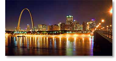
Let me first say that from the photo here compared to the one in yesterday's report, you can see the Gateway Arch is indeed lit up at night, contrary to what we were told on our arrival here, so this is pretty much the photo I had in mind before we got here.
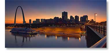
Anyway, back to my interstate walks, there are a number of ways to get from the RV park to downtown Saint Louis on the other side of the Mississippi River, but the best way, as we've been told, is to take the metro train, which conveniently has a station on the other side of the casino grounds. The station is built into the lower level of the Eads Bridge, which the train runs on along with cars and pedestrian traffic that use the upper level, and I've found it's just as easy to walk across the bridge (about a mile or 1.6 km) than it is to fool around taking the train, not to mention it saves the $4 cost of the round trip, while also presenting the best view of the skyline that I've been able to find for photographing.
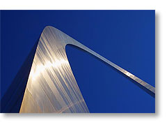
So, yesterday I was up on the bridge for sunrise photos of the skyline and decided to walk across to downtown and take closeup photos of the Gateway Arch in the sunrise light and ended up staying until the arch opened for the day at 9am and took the tram up to the top of the arch. The tram ride was a memorable experience in itself, five people being crammed into a very small circular car about the size of a large beach ball (click here to see my photo of it), but it also had windows so you could see the interior structure of the arch as it moved past and I was surprised by how complex it was on the inside for being so clean and simple on the outside. There are also stairs that go all the way up, but I sure wouldn't want to ever have to use them.
 While on the grounds, I asked a couple of the rangers (the monument and grounds are overseen by the National Park Service) why the arch wasn't lit up and night and they told me that it was and only on certain occasions was it not, so I don't know why it wasn't lit up the night before and neither did they, but I at least now had some hope of seeing it lit up before we left.
After I returned to the RV, we decided to check out the exit route we planned to take when leaving the city and it's a very good thing we did because the ramp we would have been using was closed and they gave no detour or directions to an alternate ramp, which would have been devastating had we encountered this while towing because this area of East Saint Louis is not only a slum but a mind-boggling can of worms of surface streets, freeways, and freeway ramps that only the locals could possibly be familiar enough to navigate through. So the easiest way out is the way we came in which we can take to the bypass and avoid the city entirely.
While we were out finding our best exit route we also found a source of propane at a Flying J truck stop off the bypass. We desperately needed propane, one tank being empty and the other dangerously low due to the cold nights we've been having. The RV park here has a lot of things, but propane isn't one of them.
Then after returning to the RV, Sandra decided she'd like to see the Arch up close too, so across the bridge we went, for my third time walking from Illinois to Missouri and across the Mississippi River in the process (actually that's six times walking across the river when considering the return walks). She was suitably impressed with the arch and the grounds around it, the whole thing (including the adjacent Old Courthouse) being called the Jefferson National Expansion Memorial, as if anyone would ever call it something like that when The Arch or even The Gateway Arch is so much simpler.
After dinner back at the RV, I went outside and, it then being late twilight, saw that the arch was indeed lit up, so although my feet were complaining quite forcibly about the abuse I'd heaped on them the last two days, I returned once more to the bridge to get a photo of the arch lit up at night, so now I can leave here happy.
To view my gallery of Saint Louis photos, click here.
For Sandra's account of the day, click here.
Now at Saint Louis
 Monday, 29 October 2007 - After visiting with my family for two days in Ohio (I have nothing to add to what Sandra wrote about the visits, so see her blog for details by clicking here and here), we left Columbus, Ohio bright and early yesterday morning at 8:00am and headed west for Saint Louis, Missouri, although the plan was to stay at the RV park on the grounds of the Casino Queen casino in East Saint Louis, Illinois, which is directly across the Mississippi River from Saint Louis, Missouri and I figured it should give me an excellent view of the Saint Louis skyline and its famous Gateway Arch.
Everything went according to plan except for the anticipated view, but the drive was almost uneventful except for having to scrape frost off the truck windows before we left. Click here to see the route we took, which was almost entirely along I-70. The only thing of note was having to run yet another gauntlet of concrete barriers just north of Dayton, Ohio that lined both sides of a 10 mile (16 km) long road work zone, which I negotiated once again with my nerves intact. That might have been a different story if, as in the past, an 18 wheeler had tried to pass me along there, but happily it was Sunday and there were far fewer of them on the road than normal. Sunday is definitely the best day of the week to tow a large RV.
Anyway, the day was bright and sunny and we made the 407 mile (655 km) drive in 8 hours for a 51 mph (82 kph) average speed and we got 13.5 mpg average mileage, making one fuel stop at a Flying J truck stop and several pitstops at rest areas along the way. This drive was about 100 miles (160 km) longer than we like to make, but was worth the added effort to get into position for the Saint Louis photos I want to take.
The casino's RV park is quite nice although the directions we had didn't match was what we found when we got here. There's been a lot of construction in the area, so I suspect the streets have changed, but since at that point we could see where we wanted to go we quit trying to follow the directions and simply followed our nose.
All sites here are pull-through with a clear view of the satellites, so we were onsite and setup quickly but then I ran into some difficulty when accessing the internet satellite. I had found it easily, had gotten a good signal, and things were cruising right along until I couldn't get the 'cross-pol' setup to run. I had exactly the same problem a while back when a solder connection inside the transmitter broke and I actually had to get in there and resolder it. However, I didn't feel that had happened again and the cables checked out okay (switched the receive and transmit cables and still had the same problem), so before calling for help I tried one last trick I've learned and that is run 'Force Ranging' and that got things working.
Then I hooked up the router and things quit working again. After years of experience, I assumed the problem had to be an ethernet cable gone bad and that proved to be the case. The culprit was isolated by again swapping cables until it became clear which one was bad.
Fortunately, accessing the TV satellite was about as painless as that one can be.
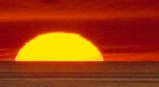
Then after a quick dinner shortly before sunset, it was off to see what kind of view I had of the Saint Louis skyline and that's where I ran into my biggest disappointment of the day. The casino is no longer on a riverboat in the Mississippi River, which would have provided a fabulous view of the skyline with the river in the foreground, but has been relocated into a new much larger building on land near the boat and now there is nowhere along the river in this area that has public access that I can find. The casino security driver who drove me around said my only real choice now was from the nearest bridge over the river. So he dropped me off there and I walked along the bridge and the view is okay, as seen above, but not what I was wanting. I also learned the arch is not lit up at night, although I've seen photos of it where it was, so that too was rather disappointing.
Today, we are planning to see the sights and then continue on with the westward trek tomorrow.
Please note we're now on Central time, an hour behind Eastern.
Click here for Sandra's account of our drive to Saint Louis.
__________________________
For Older News
To read details of our previous stops and camps, visit the News Archives.
Updated
Copyright © 2007 by Gordon L Wolford .
All rights reserved.