
Covering...
Early February 2008

Feedback
Just want to say 'Hi?'
Suggestions?
Comments?
 Our Photos Online
My avocation during our
travels is photography,
but Sandra is also taking
photos. Click the links
below to see our galleries
Sandra's Photos
Gordon's Photos
Sandra also posts her own news page
which can be read at this link...
Sandra's Nightly News
Items below are updated on average
once to three times a month...
 Didya Know?
Dolphins sleep with one
eye open, eat an average
of 66 pounds of fish a day
and are capable of diving
as deep as 1,000 feet.
Tequila is not made from
cactus, but from agave;
the best tequilas are
100% blue agave.
 A Spot 'O Humor
A backward poet
writes inverse.
A chicken crossing the
road is poultry in motion.
 Parting Thot
I have never been lost,
but I will admit to being
confused for several
weeks.
– Daniel Boone
Cast of Characters
For those reading this page who might
not be familiar with the people in
my life, these are who I often refer to
without noting who they are
(in alphabetical order)...
Becky - Nick's wife
Betty - Sandra's older sister
Caden - Grandson
Carol - my younger sister
Danica - Margie's daughter
Eric - Son-in-law
Faith - Granddaughter
Garth - Betty's husband
Grace - Granddaughter
Ian - my son
John - Margie's husband
Lillian - Granddaughter
Luke - Grandson
Margie - Sandra's younger sister
Michelle - my daughter
Nick - Margie's son
Rick - Carol's husband
Sandra - my most wonderful wife
Tracy - Daughter-in-law
We Get Looped
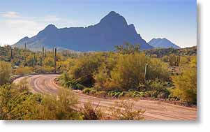 Saturday, 9 February 2008 - Looped, as in yesterday Sandra and I discovered the Ajo Scenic Loop and drove it (photo on the left).
As you can see, it's a dirt road, which the heavy duty suspension on the truck usually doesn't like much, but this road was fairly well graded, so it wasn't bad.
The scenery though was amazingly good, which is surprising because the area doesn't look particularly scenic when driving into and through the town of Ajo, the most dominant features of which are its mammoth piles of mine tailings, some of the largest in the world.
The mine in Ajo, the New Cornelia Mine owned by Phelps Dodge, is an open pit copper mine and has been closed since 1985 because the
workers voted they'd rather be unemployed than take a cut in pay to allow the mine to remain in business, so the local economy, needless to say, was seriously shafted as a result.
The mine pit is 1.5 miles (2.5 km) across at the top and 1,100 feet (335 m) deep and can be viewed from an overlook (which they call a lookout) maintained by the local chamber of commerce. So it's a bit of an irony that it was while viewing all the ugliness of the mining effort that we were told about the town's scenic loop and to discover an area as beautiful as the effects of mining are ugly.
That was in the afternoon. Earlier, I had been up and out hunting for photos at first light, driving from Why through Ajo to see the Crater Range of volcanic rock formations about ten miles north of Ajo, after which I returned to Ajo to take a few photos there because the downtown plaza and the area around it are fairly interesting.
Then it was back to the RV to help Sandra haul the dirty clothes down to the laundromat in the RV park and while she was doing the wash I headed down to get my first look at Organ Pipe Cactus National Monument.
That turned out to be a pretty drive, but disappointing because there were very few organ pipe cacti to be seen from the road and it was specifically to see this fairly rare kind of cactus that brought us here. I didn't really get a good look at any until I got to the Visitor Center where a few were near the building and in the garden behind it. Hardly an overwhelming presence. In the Visitor Center they said I'd have to take the Ajo Mountain Loop drive to get to where the cacti are.
 The Visitor Center is only about 5 miles (8 km) from Lukeville at the Mexican border, so I had just enough time to drive down there in order to see it (and found little more there than just the border crossing) and to be able to say I'd seen Mexico before having to be back to the RV park by noon to help Sandra haul the wash back to the RV.
Around mid-afternoon, Sandra then went with me to the Cabeza Prieta National Wildlife Refuge visitor center, where we learned that since the refuge is within the air space of the Barry M. Goldwater Range (the bombing kind, not to be confused with the mountain kind) and the fact that because it's considered a wilderness area as well as being full of hazards not only from venomous wildlife but unexploded ordnance, there are so many warnings, limitations, legalities, permits, wavers, guidelines, rules, and regulations that must be taken into consideration we decided it wasn't worth the bother for people like us who simply wanted a casual look at the place. After watching their video presentation, I figure we're not missing anything we can't see where we can go around here with no complications involved, like the national monument.
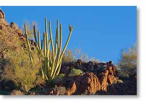
However, there is one thing I've found misleading about the monument, at least from the information I've seen on the internet, and that is it leads you to believe the monument contains most of, if not all, the organ pipe cacti that are to be found in the wild this side of the Mexican border. Apparently it is common down there, but rare up here, however at this point I saw far more organ pipe cacti along Ajo's Scenic Loop than I did in the national monument. In fact, there are even several clusters of it right here in the desert (photo above left) within easy hiking distance from the RV. Granted, both Why and Ajo are only a few miles from the monument, but still...
After passing on the wildlife refuge and touring the good, the bad, and the ugly of Ajo, we then toured Why, which took all of about two minutes, and from there drove back to the monument to show it to Sandra and see how it looked in evening light. Sandra did spot a few clusters of organ pipes that I had missed due to having to keep my eyes on the road, a good thing to do while driving, but the organ pipes were still few and far between. We will have to take the Ajo Mountain Loop before I can give a fair evaluation of the monument.
I was told about our local organ pipe cacti by Kelly, wife of Al, who along with their dogs Checkers, Cora, and Max comprise the Bayfield Bunch, fellow RVers who are also escapees from Ontario's winter and here at Hickiwan Trails RV Park. In fact, if it hadn't been for their blog we would have had to call the RV park to get directions because there were otherwise none to be found anywhere else on the internet and most of what is there has no usable address and to make it worse, lists the location as Ajo, when in fact it is miles away in Why. Fortunately, Al and Ray (another RVer) are trying to get such puzzling things straightened out and organized.
So far today, noon as I write this, I've done little other take a sunrise hike to shoot a photo for posting to my Photo-a-Day gallery on PBase.com and to work on getting this page updated and that may be all I do today. The weather has warmed up again, which is pleasant, but the sky is cloudless, which while being bright and cheery, is not the best for photography, which needs some clouds to be interesting, but not solid overcast, which is even more boring than clear blue.
Anyway, for Sandra's account of yesterday, click here.
Now Near Why, Arizona
 Thursday, 7 February 2008 - Yes, that's really the name of the town. Why, you ask, would anyone name a town Why?
It might have been in honor of Abbot & Costello's left fielder in their 'Who's On First' comedy skit, but Why was actually named for the 'Y' intersection where the two major roads in the area (the only major roads in the area actually) came together, but Arizona law requires at least 3 letters in city names, so the 'Y' was spelled 'Why', and that's the why of Why if you were wondering why.
Okay, now that I have that out of my system, we left Mesa this morning around 9:50am and arrived here at the Hickiwan Trails RV Park around 1:15pm, taking three and a half hours to make the 176 mile (283 km) trip, averaging 50 mph (81 kph) and 13.4 mpg (21.5 kpg), which is about average for us while towing. Click here to see the route. The RV park is surrounded by desert, with little else but the highway within sight of it.
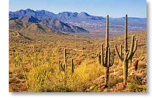
Why, two miles (3 km) away, is located in southwestern Arizona, not far from the Mexican border. This is an extremely remote area with little but the Cabeza Prieta National Wildlife Refuge to the west that lies within the air space of the huge Barry M. Goldwater Range to the north and west (all the way to Yuma, the range serving the U.S. Air Force and Marine Corps as an armament and high-hazard testing and training area), the Tohono O’odham Indian Reservation to the east (nearly all the way to Tucson), and the Organ Pipe Cactus National Monument to the south (all the way to the Mexican border). The only town of any size for miles around is Ajo (Spanish for garlic and pronounced AH'-ho) with a population of something over 3,000. It is the Organ Pipe Cactus National Monument we are here to see and photograph, although we'll also be giving the wildlife refuge a look.
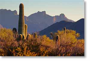
Photo above was shot out in the desert near the RV and I think the mountains are part of the Ajo Range.
We Get Snow...The Good Kind
 Wednesday, 6 February 2008 - And the good kind of snow is the kind you can see and enjoy its beauty but don't have to shovel or drive in it.
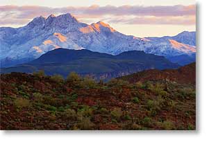
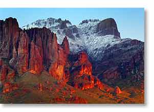
All the rain we had Monday at lower elevations fell as snow above 4,000 feet (1,200 m), so for the first time in this area we saw snow on not only Four Peaks, at 7,657 feet (2,334 m) the highest summit in the Phoenix region and shown in the photo on the left, but also on Superstition Mountain, 5,035 feet (1,533 m) and shown in the photo below.
Pass Mountain, 3,296 feet (1,000 m) and the closest mountain to us, which I'd say we're in the shadow of except it's north of the campground so its shadow hasn't actually fallen on us, isn't quite tall enough to have gotten snow. The RV is currently at 2,000 feet (610 m), near the top of Usery Pass, 2,119 feet (645 m), so we were safe from having that dreaded white stuff fall on us. By comparison, we are 760 feet (230 m) above the city of Mesa, which is at 1,240 feet (375 m), so we get a pretty good aerial view of it, which is quite pretty at night with all the lights shining below us.
Anyway, knowing the snow wasn't likely to last long once the sun came out again, we grabbed our cameras as the rain was ending Monday evening and drove over to Superstition Mountain to get closeup photos of its snowcap. The weather conditions had potential to produce a rainbow, and I had visions of one arcing over the snow capped Superstitions, but sadly the rain ended before the sun appeared and no sun, no rainbow. We did, though have a brief sunset that gave us a few minutes of great light on the mountain, as seen below where the setting sun made it look like the rocks were on fire, which seemed appropriate for a mountain born of fire.
I Flirt With Danger
Then yesterday morning I was up and on the Apache Trail before the sun came up, looking for a good vantage point to get sunrise photos of Four Peaks with its snowcap. I did find one and was even in position just as the sun was starting to clear the horizon and got the photo above.
 I then took 'the Trail' past Canyon Lake and through Tortilla Flat, where Tortilla Creek was crossing the road in what could almost be described as a torrent. However, knowing the road there has a thick concrete base which serves as a low dam (why they didn't put a culvert through it when they built it is a mystery to me) and still being able to see the painted lines of the road, I went through it and then encountered another crossing in a mile or so that also looked safe enough, so I crossed it too and drove on as far as the end of the pavement, five miles beyond Tortilla Flat. I didn't dally though, for fear the snowmelt would soon make the crossings impassable and indeed, by the time I got back to Tortilla Creek it had risen noticeably. It was still passable since the truck is quite heavy and has good ground clearance, but I'm glad the water was no higher and not running any faster. A passenger car would definitely have had serious trouble with it.
However, the water crossings were not the real danger to the drive. The temperature when I left the RV was just above freezing, in fact I had to scrape frost off the truck windows before I could leave, and since the roads were still wet in places from the rain on Monday, I had to be very careful not to hit a patch of black ice at an awkward moment. At one point in the mountains, the temperature did drop to freezing and I did hit some black ice where I found out the ABS system on the brakes actually works, but fortunately the moment wasn't an awkward one.
I went out again for sunset last evening, but as I had suspected, most of the snow had already melted off and the summits of Four Peaks were shrouded in clouds, so I was glad to have gotten the photos I did while the getting was good.
Goodbye Mesa
Today is to be our last full day in Mesa. We are planning to take advantage of it by driving back over to the towns of Cave Creek and Carefree to give them a closer look. Our six week stay in Mesa though has been a great one and we've both enjoyed it immensely, even though the weather hasn't been all that great. Nor has it been all that bad. Fairly cold nights, which isn't unusual for desert nights, but with days that could best be described as mild, not warm except in direct sun. Certainly better than up north though, so I'm not complaining, but nothing like the weather southern Florida enjoyed. On the other hand, we haven't been bothered by insects and Florida doesn't have awe-inspiring mountain vistas, so everything in life is a tradeoff.
When we leave here tomorrow we are heading to Ajo (pronounced AH'-ho) in southwest Arizona to spend a week in and around the Organ Pipe Cactus National Monument, which is right on the border with Mexico, before heading back to Tucson where we'll likely spend the rest of the winter.
Then Gave It My Level Best
 Monday, 4 February 2008 - As in Saturday morning, I hiked eastward on the Pass Mountain Trail as far as the southeastern corner of Pass Mountain, a bit more than a mile and a half (2.5 km) according to the trail map, and compared to my hikes lately to high ground, this one was fairly level, except for having to climb in and out of several washes (i.e. ravines).
I stopped where I did because the terrain looked like it was going to turn rugged and I wasn't carrying water and this is not a place you want to get dehydrated, so knowing my limits (as Dirty Harry said a person should), I called it a hike and went back.
Then yesterday, being Super Bowl Sunday, I actually watched the game, something I haven't done in years, having lost almost all interest in sports as I've aged. However, since it happened to be played locally this year in nearby Phoenix, Arizona (actually Glendale, a northwestern suburb of Phoenix, but whoever hears of a major city's suburbs) and me being curious to see the commercials, which are usually better than the game, I watched some of the pre-game show and then the first half, having donned headphones to spare my wife the ordeal of having to listen to it, and then since we started to eat supper during halftime, she watched the rest of the broadcast with me, and I have to say that for once the game was probably as interesting as the commercials, even though I had no interest in either team. It was simply a well played game that held one's interest until the last second, with the underdog winning...an American tradition.
 However, since one of my primary reasons for watching the game was for the commercials, it's a good thing we were in the US for it. If we had been relying on the satellite TV, which comes from Canada, we'd have missed the world-class commercials and had to endure the same old Canadian commercials and plugs we've seen, at the very least, a thousand times. We get what are supposed to be US networks off the satellite but the Canadian provider replaces the US commercials with Canadian, which most of the time doesn't matter, but in this case it did, so we watched the game on KSAZ, the local Phoenix FOX affiliate.
Then, last night and today we are getting the rain we were supposed to get yesterday. Yes, you read that right...more rain in the desert. It just amazes me, but I guess it's making up for them having no rain for months when we were here two yearrs ago.
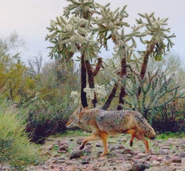
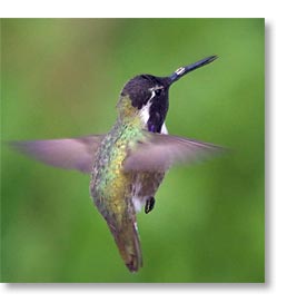
Anyway, pictured above is a bedraggled coyote that I saw in the park during a break in the rain this morning. Usually they will stop and look at me, giving me a good pose, but this one was not stopping for anything, probably looking for a place to dry out. In addition to this one, I also saw four more coyotes this morning, two of them sauntering by right outside the window beside my recliner, and while out for a short drive in the neighborhood, we saw a couple javelinas (as pecarries are called out here), the first we've seen in the wild, and the little Costa's Hummingbird above left, which dropped by to dine at our feeder. The rain must be bringing out the critters.
Taking To Even Higher Ground
 Friday, 1 February 2008 - There's a small, less than obvious trailhead at the top of Usery Pass that I've noticed several times as I've driven by it and wondered if that trail might provide a shorter path to the north side of Pass Mountain than the long Pass Mountain Trail (a 7.4 mile/12.0 km loop) that starts on the mountain's south side here in Usery Mountain Regional Park. I've been told there's a great view of the Goldfield Mountains and the Four Peaks Wilderness Area from the north side of Pass Mountain and ever since hearing this I've been quite interested in seeing if the view was worth the effort to get to it or not.
So, after lunch yesterday and feeling adventurous, I decided to see where the trail off the pass actually went, Sandra opting to stay back at the RV. As it turned out, the trail looks to be in the Tonto National Forest, which is adjacent to the park, and the trail doesn't show on the park's trail map, but that map shows the park's boundary including that area, so I'm not sure exactly who the trail belongs to, but there was no mention of a national forest fee to park at the trailhead, so I took my chances and parked there anyway.
Happily, the trail did go where I was hoping it would. Unhappily though, as is often the case in the mountains out here, it turned out to be farther than it looked, plus it climbed up the flank of Pass Mountain quite a way, so I only got as far as the northwest corner of the mountain, got a view of the Goldfields and Four Peaks, although not as good a view as I would have gotten had I gone farther, but by then (I'd estimate maybe a half mile, 1 km, and with pounding heart and gasping for breath) I'd had enough and was glad the trail was downhill all the way back.
I don't know exactly how high up the mountain I climbed, but from the topographical map of the area I'd estimate it was a change in elevation of around 300 to 350 feet, 100 meters, so quite a bit more than the 235 feet at the hill overlooking Weaver's Needle and at least double the climb up the Merkle Hills, which I do routinely and which have the advantage of no long hike to get to them.
The photo above shows part of the Lower Salt River Valley looking northwest from part way up Pass Mountain and the photo here shows Four Peaks, looking northeast from the highest point of my climb.
__________________________
For Older News
To read details of our previous stops and camps, visit the News Archives.
Updated
Copyright © 2008 by Gordon L Wolford .
All rights reserved.