
Covering...
Early March 2009
Locations during that period...
Goliad, Texas USA
Kerrville, Texas USA
Beaumont, Texas USA
Beware The Ides Of March
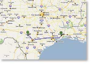 Sunday, 15 March, 2009 - That old saying ran through my head on numerous occasions today as we started the long trek back to Ontario by moving the 343 miles (552 km) from Kerrville, Texas to Beaumont, Texas (map on the left), but it was one of those good news-bad news days.
The good news is we made the trip safely and intact and in reasonably good time, leaving fairly early for us at 8:40am and checking in here at the Gulf Coast RV Resort at 3:00pm, having passed through two major cities en route - San Antonio (7th largest US city) and Houston (4th largest US city).
We took Loop 1604 around northern San Antonio, but drove straight through the heart of Houston, something I've never done before and thought since we were passing through on a Sunday and the traffic should therefore be lighter than normal, it would be a perfect opportunity to see what the downtown skyline looked like. Well, I saw it...sort of.
The bad news is it rained off and on for much of the trip and when it wasn't raining, the windshield wipers still had to run because of the spray being kicked up off the still wet road by the traffic, but all that was nothing compared to the downpour we encountered in bumper-to-bumper traffic as we went through downtown Houston. Lighter than normal...riiiiight! Sure, glad we didn't try this on a weekday. I had more than one or two white knuckle moments when it rained so hard I could hardly see the road, while fenced in by traffic on all sides going 60mph, and what the rain wasn't obstructing from view, the road spray nearly obliterated, so all I was able to see of the skyscrapers was a very quick glance out Sandra's window, a glance being all I could risk.
This was the most nerve wracking tow through a city we've done since hitting the road, with the exception of when we towed through Seattle, Washington and Portland, Oregon three and a half years ago. The downpour in Houston was thankfully fairly short-lived. Those in the Northwest went on forever, or at least seemed to.
But hey...we made it, and when all is said and done, that's really all that matters. Other than the abysmal weather conditions, the only other bumps in the road we ran into were the same horrendous dip in the road just west of San Antonio that gave me such a fright when we were heading toward Kerrville and a slowdown just east of Houston that was caused by the left lane ending at a road work zone.
At least the rain stopped while we were packing up this morning, but it wasn't so thoughtful on our arrival here as more rain arrived while were checking in and kept raining while we setup camp and did a good job of soaking us both and as I write this two hours later, it is still raining.
We are scheduled to be here two nights, to give me a day to recover physically from today's drive and to also see a couple birding areas on the Gulf Coast south of here that Hurricane Ike devastated. We are then to be leaving Tuesday morning for a return to Louisiana's Cajun Country for a few days. Fortunately, the rain is to move on to the east tonight and the long range forecast predicts sunny and warm weather.
For Sandra's account of the day and her photos, click here.
Gordon L Wolford Photography Goes Online
 Saturday, 14 March, 2009 - When I acquired my own internet domain a few years ago, the reason was twofold - 1) to contain my personal website, which had outgrown the available space where it had been, and 2) to contain a gallery of my general photography as a parallel and backup gallery to the one I maintain on PBase.com.
Moving the personal website back then was easy, simply a matter of uploading the existing files to the new domain's server, but the photo gallery was a different matter since that had to be created from scratch.
Over the years I've tried several software packages designed to create web galleries of photos and found only one I liked and that one (JAlbum) was simply too limited to give me something comparable to PBase.
The problem with PBase is it has a long history of poor and erratic performance, often being very slow, or one thing or another not working properly, or simply going down completely, and all of this without a word of explanation. They can be exceedingly frustrating. The reason I've stuck with them despite their shortcomings is that for a variety of reasons I still like them better overall than any of the other photo hosting sites around.
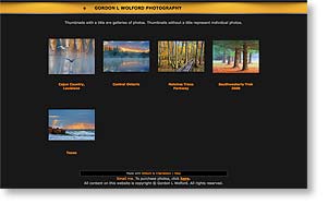
However, every time they have a serious problem it is still so annoying it spurs me into looking around for something better (but never find it) and the last time was so frustrating, I decided to bite the bullet and started to create a parallel gallery here in my own domain. Nothing is available that gives me exactly the same functionality as PBase, but the latest version of JAlbum has improved enough that what I've come up with for now is good enough. Click here if you'd like to take a look at the top level of the new gallery and click here to view the revised home page of the domain.
The new gallery has only the 800 photos I've posted since we were preparing to leave Ontario last autumn, out of the nearly 10,000 photos I have on PBase, so I've got a long way to go before my own gallery equals my content on PBase, but at least the next time their site goes down, the total presence of my photography on the internet won't go down with them.
Weather Woes
 Thursday, 12 March, 2009 - Up until 8 days ago we were having the best overall weather we've ever had for our stays in Texas, but that changed when we arrived in Hill Country. As I write this, it is midmorning and nearly mid-March and the temperature is only a few degrees above freezing - 37°F/3°C. It is also overcast, as it has been every morning we've been here, so no sunrises and we've only had a few periods where the sun came out later in the day, the only times I've had conditions suitable for photography, and only have had two sunsets, the best of which I was not in a position to photograph.
We were also going to start the long trek back to Ontario yesterday, to allow time for me to make a couple photo stops along the way, but we had to postpone our departure because rain moved in with the clouds two nights ago and it has been raining most of the time since then and I'm not about to attempt towing through San Antonio in the rain through its road work zones which were bad enough in good weather. This weather pattern is supposed to stay with us into Saturday so we are now planning to leave Sunday.
So, those are our weather woes and because of these, I've taken far fewer photos in this region than I had hoped to, but on the bright side, we have been told the area has been in drought for 14 months, so they very badly needed this rain, so I'm glad they got it, even if it has complicated things for us.
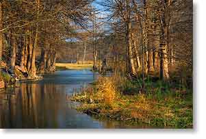
The photo above was taken three days ago, the last time we've seen the sun, and shows the channel of the Guadalupe River that runs through the RV park here.
For Sandra's account of the last few days and her photos, click here.
For the few photos I've managed to take in this area, click here.
We Get Stuffed, Then Rocked
 Monday, 9 March, 2009 - Saturday was uneventful until suppertime when we drove up to join the potluck dinner Sandra's online chat group was holding at the Buckhorn Lake Resort (a large RV park, but what's in a name) where most of them are staying. It was a most enjoyable evening with good company and good food, stuffing ourselves on it. Click here for Sandra's detailed report and photos of the event.
Then yesterday afternoon, once the morning overcast cleared somewhat, we decided to drive up to Fredericksburg and beyond to Enchanted Rock, both of which we've heard a lot about during our stay here and figured they should be next of area attractions to see.
Getting to Fredericksburg from here is easy, so I didn't study the route to Enchanted Rock too thoroughly, assuming there would be signs for it in Fredericksburg. If there were, I missed them, so out came Miss Pinky who redeemed herself somewhat for her recent failures by getting us on the right track.
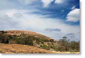
I intentionally did no research on Enchanted Rock beforehand because I wanted to be surprised by what we found there and based on past experiences with such places, I wasn't expecting to be overwhelmed, but what we found was definitely impressive...a huge granite dome that is second in size in the US only to Stone Mountain in Georgia and mostly devoid of vegetation. It stood out from the surrounding tree-clad hills like a bald man in a sea of women. Photographs, which can only show things in two dimensions, fail to convey the rock's size. Click inside the little white box in the photo above for a zoomed in view of that area which shows people on the rock and gives some idea of scale.
I, of course, had to try climbing it, while Sandra opted to stay below. I made it halfway to the summit before giving up due to lack of time, having taken no water with me, and not dressed properly for such an exertion in direct sun with the temperature at 83°F (26°C). By the time I reached my limit I was gasping, soaked with sweat, and my little heart pounding. We plan to go back someday and will allow enough time so I don't have to rush the climb.
On our way back to the RV, we drove around Fredericksburg some, making only one stop and that at the visitor's center. We found the town worthy of its reputation and it being a beautiful Sunday afternoon, the place was packed. It was founded in the mid-1800s by German immigrants and this heritage still shows. There is a very nice RV park south of town in the Lady Bird Johnson Municipal Park and that's a place we are considering for a stay sometime in the future. The LBJ Ranch is only 16 miles east of town, so like the name of the park, the town shows their influence on it in many ways.
For Sandra's account of yesterday and her photos, click here.
For my photos taken in this area, click here.
We Find The Maples
 Friday, 6 March, 2009 - Today, after the morning clouds cleared and we managed to get the TV dish set up (the cable TV supplied by the RV park is really abysmal, as is the wi-fi), we headed out at 2pm for a scenic drive along the south fork of the Guadalupe River, hoping to get as far as Lost Maples State Natural Area (SNA). This drive was one recommended by the staff at the Kerrville Visitor Center and the drive did indeed prove to be quite scenic...once we got beyond the clutter of civilization and entered an area of large ranches where the scenery was largely unspoiled.
Large stretches of the Guadalupe River in this region are lined by cypress trees and the water, being near its source, is uncharacteristically blue for a river, looking more like the blue of an alpine lake, so it's quite a beautiful river. But as happens far too often, the beauty is either obscured or marred by non-stop human development and inaccessible because it's banks are mostly private property, which all had no trespassing signs posted.
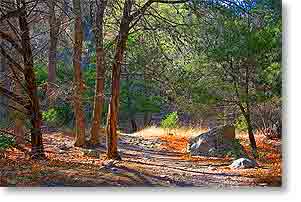
Anyway, before this report devolves into a rant, the drive from our RV park west of Kerrville to Lost Maples SNA takes an hour, so it was mid-afternoon by the time we got there, which didn't leave much time to see the sights, but we did have enough time to hike the Maple Trail (photo above), which wound its way through a lovely boulder-strewn canyon for 4/10 mile (6/10 km) along the west side of the Sabinal River. The scenery was quite beautiful and we felt like we were actually in the far west. Why Lost Maples is called a state natural area rather than a state park is lost on me. I'm sure there's a distinction, but it seemed to have everything you'd expect to find in a state park, including an entrance fee, which happily was covered by our Texas State Parks Pass.
The maples (Uvalde Bigtooth Maples and I have no idea why they are called Lost Maples) didn't look to our untrained eyes much like the maples we are used to seeing back east, but apparently bigtooth maples can also be spectacular in the autumn and the SNA can get quite crowded with people viewing the fall foliage. At this time of year though, the maples were just starting to bud and we had the trail to ourselves.
The Maple Trail ends where it intersects with the much longer East Trail, which can be taken if one wishes to continue on hiking into the interior of the park or one can take it back to the parking lot since it parallels the Maple Trail but along the east side of the Sabinal River, which is what we did. It really was a memorable hike.
By that point, it was time to head back to the RV, so we took the alternate route back to Kerrville, this one forming the bottom section of a 100 mile (160 km) loop via Vanderpool and Medina and getting us back to the RV just in time for supper. All in all, it was a most enjoyable afternoon.
For Sandra's account of the day and her photos, click here.
Hello Hill Country
 Wednesday, 4 March, 2009 - Today we packed up, hitched up, said goodbye to Goliad, and made the 178 mile (286 km) move to Kerrville in the area of central Texas known as Hill Country, a region of the state we've never seen before.
Click here to see a map of the drive, which was mostly uneventful except for one heart-stopping moment in a road work zone west of San Antonio where I10 was lined with concrete barriers right up to the outside edges of the lanes which shifted with us in the outside lane and a car next to us on the right and without warning while in the turning of the lane shift the road had a couple of sharp dips that bounced us violently around and I don't know how the RV managed to stay hitched and not hit either the barrier or the car, but we made it through unscathed except for my nerves. Sandra had no idea how close a thing it actually was.
Anyway, we left Goliad at 10:20am and arrived at the By The River RV Park & Campground around 12:45pm. The weather was perfect for the drive and the park is nice. Not great, but nice. It has free cable TV, but only 12 channels of it and they aren't all that clear. I'll be putting up the TV dish tomorrow. The park also has free wi-fi, which I was able to log onto once, but now can't, although Sandra has no trouble. We are now using different versions of the Mac operating system, because with the new computer I am forced to use OS X 10.5.6 and many things don't work as they should and I really dislike it but have no choice but to use it, while she's still running tried 'n true OS X 10.4.11 like I was on my old Mac and never had any trouble with it. Hopefully, they will eventually get OS X 10.5 to work properly.
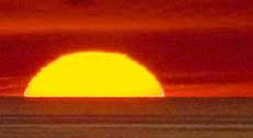
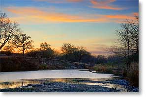
Okay, enough technical whining. The park here for being on the banks of the Guadalupe River isn't at all scenic like we're used to, except for the view people have who are backed up to the river (and those sites were all taken) and the sites are packed in tighter than we like (although not nearly as tight as some we've seen), but the park does have one excellent feature and that's a good size island in the river. The island is fairly open and presents some good uncluttered views of nature, like the one above of sunset this evening, taken from the little bridge over to the island, the island being on the left.
We are here primarily for an in-person gathering of some members of the online RV chat room Sandra hangs out in, plus (as I said above) this is one region of Texas we haven't seen before and it's highly considered by a lot of people for its scenic beauty. So far, we haven't found much of that, but we only just got here so I expect we will be finding some of it in the near future.
For Sandra's account of the day and her photos, click here.
Our Stay At Goliad So Far
 Monday, 2 March, 2009 - The most noteworthy thing about our stay in Goliad to this point has been the extreme weather shift. We've gone from torrid summer weather in the upper 90s F (mid 30s C) and running the air conditioner and being able to sleep at night with the windows open to temperatures at night dropping to freezing as it did last night and the furnace running. I didn't thaw out yesterday morning from my sunrise walk until afternoon.
Otherwise, we've done nothing terribly exciting, just puttering and hiking around the area, seeing the local sights. I walk up to the mission several times a day, just because I can, and Friday I toured the Presidio La Bahia, the other main attraction here, and we've been downtown a few times.
The town square in Goliad is fairly interesting, complete with a vintage courthouse and an authentic old wild west hanging tree that saw lots of documented action during the mid-1800s, but today thrives in its retirement and still growing old gracefully. I find it ironic that this tree which was an instrument of death in so many cases (ranging from dozens to as many as something in the low hundreds, depending on whose count you use) is a species called Live Oak.
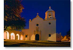
Then last evening, right after sunset, I got motivated to see if there were any opportunities around here for night photography and found a couple, one being the photo above of the mission. The back of the compound (behind what you see above) is the side that's brightly illuminated, since it's the side that faces the road. This side had only incidental and indirect light on it, but thanks to Mr Tripod and a long time exposure, I got a usable image. This is actually much brighter looking than it was to the eye.
For Sandra's account of the last few days and her photos, click here.
For my photos taken in this area, click here.
__________________________
For Older News
To read details of our previous stops and camps, visit the News Archives.
Updated
Copyright © 2009 by Gordon L Wolford .
All rights reserved.
Sandra also posts her own 'blog' (news
page), which can be read at this link...
Sandra's Nightly News
My Photos Online

During our travels, my
avocation is photography.
Click the links below
to view my photos or to
ask about purchasing
any of them.
Gordon's Photos
Purchase Inquiry

Feedback
Just want to say 'Hi?'
Suggestions?
Comments?
Items below are updated on average
once to three times a month...
 Didya Know?
Months starting on Sunday
will have a Friday the 13th.
Easter is the first Sunday
after the first Full Moon
after March 21.
The average uterus during
pregnancy, expands up to
500 times its normal size.
 A Spot O' Humor
Baby Boomers
Then & Now
Then: Acid rock
Now: Acid reflux
 Parting Thot
We cannot always build
the future for our youth,
but we can build our
youth for the future.
– Franklin D. Roosevelt
Cast of Characters
For those reading this page who might
not be familiar with the people in
my life, these are who I often refer to
without noting who they are
(in alphabetical order)...
Becky - Nick's wife
Betty - Sandra's older sister
Caden - Grandson
Carol - my younger sister
Danica - Margie's daughter
Eric - Son-in-law
Faith - Granddaughter
Garth - Betty's husband
Grace - Granddaughter
Ian - my son
Iris - Granddaughter
John - Margie's husband
Lillian - Granddaughter
Luke - Grandson
Margie - Sandra's younger sister
Michelle - my daughter
Miss Pinky - our GPS navigator
Nick - Margie's son
Rick - Carol's husband
Sandra - my most wonderful wife*
Tracy - Daughter-in-law
*(a.k.a. 'Grammy' to some)